
Corraun Hill [Cnoc an Chorrain]
Good walks are even better shared.
Overview
Corraun Hill [Cnoc an Chorrain]
Nestled snugly in the Irish Coast Mountains, Corraun Hill stands tall at 537 meters, making it a commendable destination for any hiking enthusiast. Known as Cnoc an Chorrain in Irish, translating to 'Hill of the Top,' this Marilyn offers more than just a good leg stretch - it rewards with astounding panoramic views and a bit of geological history to boot!
Geology
What makes Corraun Hill particularly enchanting is its rocky terrain, primarily composed of ancient igneous rock. The surrounding landscape whispers tales of volcanic activity from eons ago, with the occasional dramatic cliff adding to the rugged beauty. Ensure to keep your eyes peeled for fascinating rock formations that highlight this rich geological heritage.
Routes
The most popular route begins at Corraun Point, where a well-defined path guides hikers to the summit, covering a distance of about 10 km. The trek usually takes around 3.5 hours, depending on how many times you stop to take photos (and we all know you'll stop quite a bit!). This route is rated as moderate, so lace up your hiking boots and prepare for a rewarding walk!
Summit Features
Upon reaching the summit, hikers are greeted with a glorious sight. The cairn, a traditional pile of stones, marks this high point and serves as a perfect backdrop for those celebratory selfies. Besides the rocky cairn, the views from here are nothing short of breathtaking!
Terrain Type
Expect a combinational treat of grassy expanses alongside tumbling rocky outcrops. Keep your wits about you as some areas can be boggy, especially following a heavy rain - it's all part of the adventure, right?
Views
And oh, the views! Those standing at the top can feast their eyes on the stunning Clew Bay, scattered with islands and the distant rugged peaks of the Mweelrea Mountain range. The best times to soak it all in are between late spring and early autumn when the sky decides to put on a show during sunrise or sunset.
Hazards
As with any adventure, a few precautions are wise. Be aware of the uneven terrain, and don't be shy with your safety gear for those slippery spots after rainfall. Mapping your route beforehand can make sure you're not up a creek without a paddle!
Nearby Summits
Nearby, you’ll find other noteworthy peaks. Croagh Patrick, a famous pilgrimage site, and Mweelrea, the highest mountain in Connacht, await your exploration.
Access
For those driving in, parking can be found at Corraun Point, though be prepared for it to fill up quicker than a kettle with a broken lid on Sunday mornings! If public transport is more your style, local bus services offer connections from Westport, but don’t forget to check the local timetables.
Facilities
The quaint town of Louisburgh is the closest pit stop prior to your hike and is equipped with charming cafés and shops where you can stock up on gear or grab a snack to fuel up.
History
Delving into history, Corraun Hill is steeped in local legend and culture. Its name reflects its height and position, making it a key landmark in the region's landscape. So not only do you get exercise, but you also partake in the area's rich heritage!
In summary, Corraun Hill is a hidden gem, filled with history, stunning views, and a few charms to make your hiking experience both memorable and enjoyable. Now, get out there and tackle those trails!
Explore routes near Corraun Hill [Cnoc an Chorrain]
Public walks starting within 80 km of this hill. Nearby does not mean a route reaches the summit; check its map and access before setting out.
No public routes are currently listed within 80 km of Corraun Hill [Cnoc an Chorrain] on Walkmates. This does not mean there are no paths here. Explore the map and check local access information before planning a walk.
Route planning notes
These notes describe possible approaches, not verified navigable routes or permission to cross land. Check current paths, local access rules and conditions before setting out.
Corraun Point to Summit
A well-trodden path offering breathtaking views of Clew Bay and the Atlantic.
Make a day of it, together
Find someone to share the walk with, or organise a day out along a route you like.
Hill facts and local notes
Classifications
Elevation
524m
1,719 ft
Prominence
103m
Coordinates
53.8985, -9.8963
L754960
OS Map
30
At the Summit
The summit features a prominent cairn, which has become a beloved picture spot for hikers, along with sweeping vistas of the surrounding landscapes.
Terrain & Geology
Primarily composed of igneous rock, Corraun Hill showcases a rugged landscape formed from ancient volcanic activity, with stunning cliffs and interesting rock formations illuminating its geological history.
Views & Scenery
From the summit, one can see out over Clew Bay, the rugged coastline, and the distant peaks of the Mweelrea Mountains.
History & Heritage
Name Origin
The name Cnoc an Chorrain translates to 'Hill of the Top' in Irish, reflecting its prominent position in the landscape.
Historical Significance
Corraun Hill holds cultural significance especially for local hikers and outdoor enthusiasts, often featuring in local folklore.
Getting There & Facilities
Check current local access restrictions, parking rules and transport timetables before travelling. These notes do not confirm public access to the summit.
Parking
Parking is available at Corraun Point, with space for several vehicles, though it can get busy during weekends.
Public Transport
Bus services run from Westport to the vicinity, but check local timetables as services may vary.
Nearby Facilities
Louisburgh provides basic facilities including cafes, shops, and toilets; perfect for a pre-hike snack.
Safety Information
Known Hazards
- Uneven and rocky terrain can pose challenges; be cautious of slippery paths after rain.
General Safety Tips
- Check weather conditions before setting out
- Carry appropriate clothing and equipment
- Let someone know your planned route
- Take a map, compass, and GPS device
- Carry emergency supplies: food, water, first aid kit, torch
Hills
Some common questions about the hills answered
Are there group walks up Corraun Hill [Cnoc an Chorrain]?
Many walkers use Walkmates to join or organise walks with others. You can check for group walks around Corraun Hill [Cnoc an Chorrain] through the maps
Are there other walkers around Corraun Hill [Cnoc an Chorrain]?
Activity varies by location and time, but Walkmates lets you see whether others have shared walks or shown interest in this area. Find other people through the walking friends search walking friends for Corraun Hill [Cnoc an Chorrain] search or of course create your own walk for Corraun Hill [Cnoc an Chorrain]
Can I organise a walk to Corraun Hill [Cnoc an Chorrain]?
Yes. If there aren’t any walks listed already, you can create a walk and make it available for others to join.
If you're signed up to Walkmates, you can create a walk to Corraun Hill [Cnoc an Chorrain].
How do I find a walk up this hill?
There are often multiple ways to walk this hill, depending on experience and route preference. Walkmates helps you explore walks and routes that others have shared.
Can I suggest a new route up Corraun Hill [Cnoc an Chorrain]?
Yes. You can suggest or create routes to share with others. Walkmates focuses on the social side of walking, so routes are used to help people organise walks and explore areas together, rather than as detailed navigation tools or route libraries.
Other uses really appreciate knowledgeable walkers sharing their routes. Share your favourite route to Corraun Hill [Cnoc an Chorrain] here
The is an error or something incorrect about this hill. How do I let you know?
We always strive to keep the information on Walkmates as accurate as possible. If you find an error, please let us know through the contact form and we'll aim to correct it as quickly as possible
Community Discussion
Comments
Location
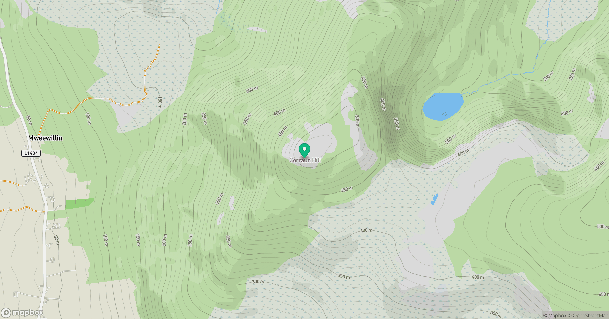
Grid reference: L754960
View on OpenStreetMapOpens a map in a new tab, centred on the hill.
Hills within 30 km
Straight-line distance, not a walking route or confirmation of access.
No comments yet. Be the first.